JIM Shortlisted to Develop a Plan for Newton
Developing a Transit-Oriented Framework for Newton
As a small practice, we rarely get to engage in larger urban projects. However, we have been fortunate to have the opportunity on several occasions, and here we were shortlisted to develop a plan for Newton Town Centre. Although we ultimately were not selected, the RFP gave us the opportunity to articulate our approach to such projects. The text below is adapted from the RFP, with revisions for clarity, for those unfamiliar with the project.
Our approach to urban planning and design is simple. We believe great cities are founded on rich, connected landscapes, efficient, safe mobility networks, and vibrant, inclusive public realms. Only after we have laid those foundations can we build a successful community.
We believe great cities are founded on rich and connected landscapes, efficient and safe mobility networks, and vibrant and inclusive public realms.
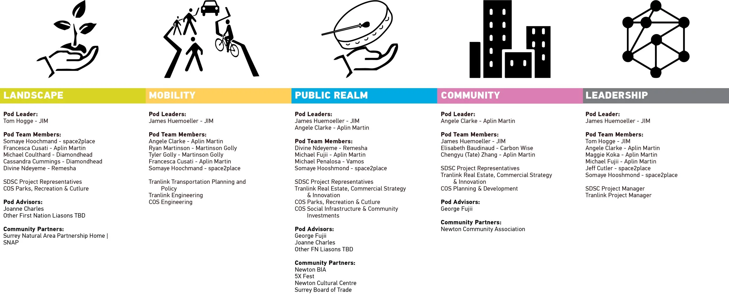
This view shapes our approach. To develop these four project components, we structure teams for planning projects around four topical “pods” and a leadership pod with the following tasks:
Leadership Pod: Overall coordination, scheduling
Landscape Pod: Environmental and habitat enhancements, park and plaza designs, trails and paths
Mobility Pod: Traffic analysis and design, BRT integration, Transit station design, active transportation strategy, mobility hub/parking analysis
Public Realm Pod: Cultural considerations and retail strategy
Community Pod: Land-use, housing type and tenure mix, community amenities
This structure has proven successful for JIM, ensuring conversations are focused and productive. This structure serves as the basis for the RFP.
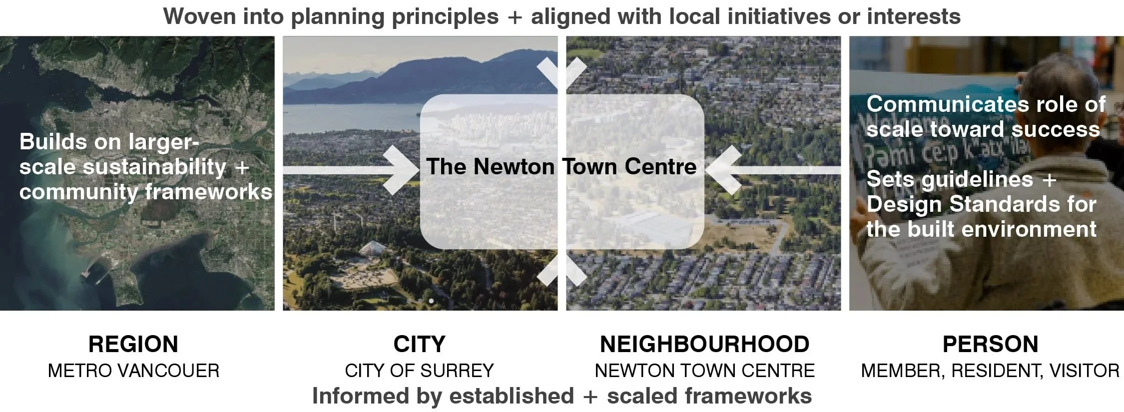
The ambitions of the Framework Planning Project for Newton Town Centre, as laid out in the RFP, were clear: The City of Surrey (CoS), Surrey City Development Corporation (SCDC) and South Coast British Columbia Transit Authority (TransLink) were looking for a service partner, or planning team, to build on the Newton Town Centre Plan (Newton TCP) to generate a vision for the Newton Town Centre that creates a vibrant, identifiable transit-oriented destination. The vision was to consider integrating a new transit node, revising the existing civic infrastructure, including the new community centre, and future commercial and residential development. It should also carefully consider cultural aspects that celebrate the diversity of the Newton community, including the local Indigenous communities on whose traditional lands Newton now sits, and sustainable approaches to the development.
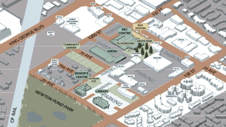
These goals were ambitious but justified, given the project’s potential. Newton, the only town centre within Surrey that lacked a core before its incorporation, is a vibrant, growing community that needs a core that matches its urban qualities. The site itself was just south of Newton’s commercial core, encompassing a series of civic structures, single-family residential homes, and open areas. The area is roughly equivalent to Vancouver’s Olympic Village planning area. Existing civic amenities include a library, a community centre, an ice rink, a gym, a wave pool, and a senior centre. The Newton Pond Park lies immediately to the south. With the existing bus exchange and community buildings, and its location along one of Surrey's main arterials, King George Boulevard, the site has the capacity to grow significantly to support the city's growth.


Student work from a 2021 studio looking at counter proposals for the proposed community centre across King George. This project preserves the exisitng facilities and connects them through a new public landscape. The redeveloped civic space then supports increased density on the surrounding lots.
The Newton TCP, which served as a reference point, is a planning document covering the framework plan site area and its surrounding neighbourhood that underwent a major revision in 2020, culminating a 12-year engagement process. A key component of the plan is the development of a Rapid Transit Service on King George Boulevard, connecting to the existing bus exchange at the north end of the site, to support the densification of the plan area. The Rapid Transit system, initially light rail, is now likely to be a Bus Rapid Transit System, with all the same amenities one would expect from contemporary BRT systems, including dedicated lanes and enhanced stations.
How can we finally begin to give Newton the core it needs and deserves?
In addition to the transit proposal, the Newton TCP outlines the area’s development, with an expected increase in dwelling unit density (DUD) from 7.3 units per hectare, a value more reflective of a small town, to 225 units per hectare. This is still short of new developments in Vancouver, such as Jericho Lands (305 units/ha), but it is a significant improvement. To enable this growth, the plan lays the framework for multimodal transportation and enhanced public spaces to complement the improved infrastructure.
Despite Newton TCP’s comprehensive nature, more work remains to be done. First and foremost, the plan needs an implementable vision that matches its ambitions. The following outlines our processes for developing that vision.
LEADERSHIP POD
Before we consider solutions, we develop a coherent outline of the project goals and values.
Defining and reaching consensus on a project’s values ensures the team is on the same page and is key to evaluating planning and design decisions. For example, these values would form the structure of the “evaluation matrix” to determine the preferred Block Plan Approach in Phase 1, as required by the RFP. The definition of the project goals or values will come from both a review of the RFP and the Newton TCP, as well as further engagement. We anticipated that a series of iterations of these values would be required throughout the project.
From Ambition to Design
Defining values is just the first step. We can all agree that sustainability is a good goal but developing an implementable plan to achieve that goal is far more challenging. As our introduction outlines, our approach breaks a project into four sections: Landscape, Mobility, Public Realm, and Community.
Although it can vary from project to project, we typically begin with the landscape as the primary means of endowing a plan with a sense of place. Once the landscape vision is confirmed, the team assesses the transit issues to be addressed. A successful plan can only occur if a strong concept of mobility does not privilege the car while acknowledging that Surrey, even with a BRT station, will still largely be car-dependent in the near future.
How can we Bring an new form of Urbanism to Newton to make it a unique destination?
Once those components are conceptualized, the team can explore methods for creating vibrant social spaces that incorporate cultural considerations and a retail strategy. Cities, at their best, are social places that encourage a dynamic public life; building around a strong landscape and enabled by a coherent mobility plan will provide the infrastructure to support the Newton Town Centre community and the broader Newton town.
The final step will be community building through housing strategies and land use. Here, the key is to ensure the Newton Town Centre remains as diverse as the larger Newton area. Finding the right density to support the amenities and retail, determining the housing mix and tenure, and identifying neighbourhood amenities that operate at various scales will be three issues explored at this phase, in addition to more general land-use definitions. Building community resilience is one driver, with the team closely examining strategies for flexibility and adaptability to respond to changing markets, needs, and tastes.
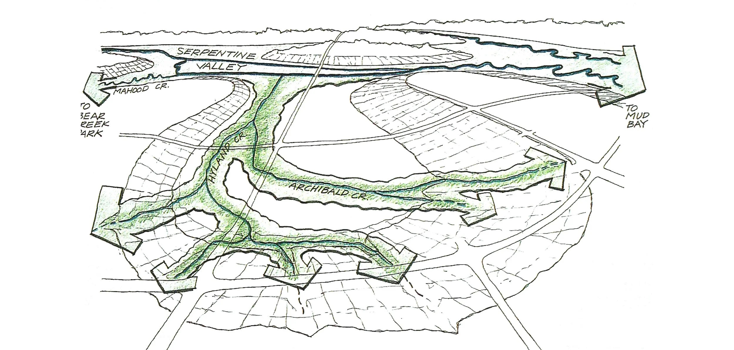
An image by William Morrish from the Design Charrette of Hyland Creek as it climbs the ridge. Newton Town Centre is to the left. Morrish was a professor with JIM’s Principal James Huemoeller who shaped much of his thinking on our built environment.
LANDSCAPE POD
In 1996, with the support of the City of Surrey and the Real Estate Foundation of British Columbia, the University of British Columbia invited planners from across North America to explore methods and ideas for Surrey’s future, looking at a project site just south of Newton TC. The formative component of each proposal centred on the existing landscape structure as a foundation for the city’s future development. Though much of the proposals is outdated, we believe the landscape's centrality to the city remains relevant and the starting point for this project.
Despite the grid that structures the transportation network, Surrey’s form is still heavily influenced by its topography. The plateau on which most of Newton sits wraps around to Whalley, now Surrey City Centre and across to Guilford, separated from the Cloverdale ridge by the Agriculture Land Reserves. Frequently bisected by development and roads, salmon-bearing streams still make their presence known, rising up from the valley to their starting points at the tops of these plateaus.
Newton TC lies at the origin of one of the more important of these streams, Hyland Creek, and could, as a result, play an important role in improving that important watershed. The Newton TCP addresses watercourse systems and identifies their value in three locations, calling for a Qualified Environmental Consultant to review them. Rather than just mitigating negative impacts, we believe in Newton, the natural and built environments can work harmoniously to create resilient, high-performance landscape systems, spaces, and cities, based on diligent and thoughtful stewardship of human and more-than-human resources.
We would argue that not only is this approach good for the Newton TC, but it’s also critical to making good cities, one that, even today, despite our concerns for the environmental impact of humans and love of great parks, remains overlooked. Proponents of Vancouverism, for example, often fail to acknowledge that many of the city's best developments depend on their proximity to the coastline to achieve the high quality of life they offer. Access to large, connected landscapes is critical to make density livable, as cities from Copenhagen to Rome to Hong Kong demonstrate.
Our approach assesses existing landscapes and determines the best way to enhance and integrate them into the Town Centre. This approach will follow our recent work on a similar project in a car-centric community in the Okanagan Valley, where we developed a series of landscape corridors, some as ecological connections and others as urban plazas for people. These corridors not only allow for movement and gathering but also ensure the dense urban blocks between maintain a direct connection to the landscape, with big views and easy access. The result is a powerful vision of the best city and landscape coming together to create a unique environment that celebrates the local qualities of the place.
Reconnect habitats
Connectivity for both habitat and recreation will be one important strategy for the team. We have outlined the existing habitats that can act as a starting point for ecological connectivity. A 2011 Environmental Management Study identified the railroad, an important landmark in the area, as one potential ecological corridor through the city, with a moderately high potential.
Can landscape connectivity create identity while making a place livable?
From a recreation standpoint, there is limited existing infrastructure in the area. The Newton TCP makes little reference to new infrastructure, noting a single proposed multi-use pathway and improvements to the street network. Certainly, the latter is important for reducing dependence on cars and will be discussed in the next section in more detail, but the former needs further exploration to ensure that new residents have access to a good trail system.
Improved Resiliency
A landscape approach is more than just parks; it's also infrastructure. The Newton TCP identifies several key improvements required to accommodate future development, including upgrades to drainage and stormwater systems, which would build on the efforts made with the construction of the Newton Pond in 2016. Improvements here should prepare the plan area for impacts associated with climate change, such as more frequent storm events like the November 17th atmospheric river.
MOBILITY POD
There is no question that, at the moment, Surrey is a car-dominated community. Any transportation concept needs to acknowledge that existing condition. However, it is imperative that reality does not prevent us from being ambitious. Over fifty percent of carbon emissions in North American urban environments come from transportation. The number only increases as the grid is cleaned up, a condition that has already occurred in BC, and as buildings become more carbon-conscious. That means there are diminishing returns to Passive House and other initiatives focused on individual structures. To improve the performance of our cities, we need to strengthen our transit systems.
Sustainability alone does not make the case for improvement. Transportation networks can also be among the biggest impediments to creating inclusive cities. There is no way around the fact that whenever the car drives, design decisions make our streets less safe for the most vulnerable. Incremental solutions to making cities more pedestrian-friendly still focus on the car.

A North American rating system used by real estate companies and planners rates Vancouver’s walkability at 79.8; Surrey’s is far lower at 46.1. The Newton TCP highlights issues with the existing infrastructure, noting that few roads have sidewalks and that the area is “a known hot spot for pedestrian and cyclist crashes.” In fact, some of the most pedestrian-friendly cities in North America still fall short of global cities that put the pedestrian first.
Of course, the proposed BRT station will go a long way towards making the Town Centre a walkable neighbourhood. As a destination, though, Newton Town Centre presents a problem, as a significant portion of the catchment for the existing and proposed civic amenities can only access those facilities by car.
Leaving the Car Behind
We have several approaches for addressing that issue. One example is integrating a Mobility Hub network into the project that provides parking and allows users to easily switch transportation modes. They often also offer amenities such as coworking space, package pickup and delivery, and cultural spaces. The parking component of these hubs should be fully adaptable for other uses, such as retail space, as car use diminishes with continued transit improvements.
Placing these hubs at the edges of the development reduces internal traffic, but they must be carefully planned to ensure the development remains well-connected. Their location will also determine their scale, which should vary depending on potential demand. Studies show that appropriately sized hubs are most effective when accessible within a 200m radius.
Transit Design Aesthetics
An efficient transit system does not begin with buses, trains, or boats. Instead, it starts with the pedestrian and cycling network that connects people to public transit. Transit will not significantly affect vehicle trips without an effective means of reaching the hubs. The design of a transit-oriented development begins with an analysis of the walking and cycling trips. Only once those systems are understood can you start looking at the transit network and interactions between cars and taxis.
After integration with pedestrian and cyclist networks, the design of the transit hub itself requires two steps. The first step for the BRT system is understanding the busway, which TransLink will outline. The second step is the station or terminal configurations, typically heavily dictated by context and the bus design. Additional considerations include intersection and signalling, bus parking terminals, kiss-and-ride, taxi/rideshare locations, and vehicular parking. Successful station design requires easy passenger access and efficient bus movement.
The project team will review and integrate Translink’s station design standards. Where standards are not provided, the team will follow industry standards, such as those set by the ITDP and APTA.
The task for the planning process is reconciling those standards with the framework plan to ensure easy access. Based on the project team’s experience, several conditions must be considered in that process. First, the station must be considered in the context of the overall project phasing, and the time horizon must be defined. Surrey is a changing community, and demands on the BRT system will also change accordingly. The second is that balancing the need to meet peak demand while ensuring easy pedestrian access and bus movement is essential. Grade crossings are more efficient for pedestrians than fly-overs, but can pose problems for bus and vehicular traffic. A solid understanding of anticipated boarding will be vital to right-sizing the facility.
Lastly, transit must be understood as an aesthetic experience. Designs that prioritize efficiency over quality create a negative view of a transit system, which can affect ridership. Replacing light rail with BRT requires convincing the public that buses can be as effective as rail. Ensuring a positive experience will make the system a success.
A benefit of high density is easy access to a vibrant public realm. Density fosters the exchange of ideas and goods, which are important parts of anyone’s daily life. Creating vibrancy requires a coordinated approach to cultural considerations and retail strategy. Both can support each other by creating active streets and open spaces.
Civic Foundation
Given several existing civic facilities and the expectations for a new community centre, the plan must leverage those amenities. First, they make the area a destination while we help strengthen the retail strategy. Second, they will directly support cultural production in the plan area by providing space. We anticipate the following approaches to begin by building around these amenities.
Cultural Considerations
We encourage an expansive view of cultural considerations. More than just art installations, creating space also means finding opportunities for cultural production. Done right, creating space for cultural production will support the arts and foster community entrepreneurship. Maker spaces and co-working sites are equally crucial to creative production as artist studios and workshops. Filmmakers, writers, gaming designers, and music producers significantly contribute to our larger Lower Mainland community.
Can culture and market join to give our public realm meaning?
Integrating opportunities for cultural production requires a commitment to identifying every available opportunity. Indeed, the civic buildings on the site can play a significant role, especially the new community centre, which will almost certainly have studio space, workshops, and even music rooms if it follows recent trends. We also see opportunities in the residential components to integrate spaces for cultural production and dissemination as flexible amenities.
A Retail Vision
A retail strategy needs to be tailored to the project’s context. The Newton TCP divides retail into two types: active and flex frontage. Active retail is small-scale pedestrian-oriented retail (max 10m frontage). Two areas are also identified as strictly zoned for commercial activity. In sum, the plan outlines an ambition for street retail, but the vision for what that looks like remains unresolved.
While new retail models may be introduced, leveraging Newton’s existing cultural and retail assets will be vital in fostering a vibrant community from day one. Shopping areas around 80th and 126th should serve as a model for retail opportunities, but within a different urban structure. In a region noted for its cultural diversity, Newton Town Centre should develop a retail strategy that focuses on those strengths.
Retail Infrastructure
Building retail space is not enough; a strategy needs to identify the type of retail the community wants and create the necessary infrastructure to encourage it. The retail strategy also needs to be realistic. Creating flexibility in the land-use plan to accommodate changing market conditions can help ensure that commercial opportunities align and that space is used efficiently.
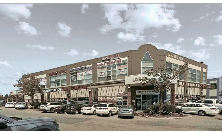
Although the Payal Business Centre does not reflect the type of urbanism we would hope to achieve for the Town Centre, it is likely an accurate reflection of the retail market in Newton and needs to be one starting point for a retail strategy.
Again, these approaches drove our work on The Bluffs. Two goals outlined in the Westbank First Nation CCP were to find more opportunities for entrepreneurship for Members and promote syilx culture. The team is focusing on encouraging creative retail support for both goals with workshops, retail units, and opportunities for cultural dissemination. A market hall and small street retail units will be leased at lower rates, subsidized by larger entities that benefit by collocating with these creative components. The ambitions will start with relatively small but flexible residential ground-floor units that can be converted into commercial space and multi-purpose ground-floor amenity spaces, extending the concept if it succeeds. The proposal builds on successful models such as Granville Island and the Talliskivi Creative City in Latvia. In those cases, subsidies are provided for certain components whose success will draw in other retailers interested in adjacency or clustering. In Talliskivi, the subsidies support creative retail that draws large retailers interested in being part of the retail community.
Street Retail Strategies
The creative retail component fits within our team’s broader retail approach to new development in street retail. Street retail is an understudied component of commercial market analysis, and far too often planners focus on design guidelines such as tall ceiling heights. We will take a more research-based approach with strategies that include:
Clustering: Encouraging both complementary and competitive clustering. The former, also called convenience retail, occurs when diverse retailers offer shoppers a range of goods and services, as is common in neighbourhood retail. The latter, called comparison retail, involves clustering for comparative shopping. Art galleries, fashion, bookstores, restaurants, and even sporting equipment retailers are commonly clustered for that reason.
Betweenness: A second strategy is to study the site’s betweenness factor and how it will shift over time. Betweenness examines the weighted values of destinations around the site and their impact on people’s movement. Placing retail along these movement paths allows them to reach a broader customer base. The new BRT station will be an essential point of reference, as will the civic spaces in the Town Centre. Mobility hubs and exterior public spaces can also be destinations within a development.
Redundancy: The final strategy is to build redundancy, ensuring successful retail that is not dependent on a single strategy and creating resiliency to accommodate future market changes. A large anchor tenant can bring in more traffic as a destination for surrounding residents. Other factors include land use analysis, with offices typically supporting more retail than residential, which can be a key consideration.
Visibility: One strategy that seems obvious but is far too often overlooked is the importance of visibility. Many large-scale developments tend to create retail centres at their core, but visibility is often best served at the project’s edges, adjacent to major transportation arteries. Though King George presents challenges, it always offers valuable insights for everyone passing by, insights that must be incorporated into the retail strategy.
Building a mixed-use community requires commercial activity and street life to make neighbourhoods safe and vibrant. We encourage active approaches that go beyond just creating space.
While the first three sets focus on building the infrastructure, the last phase is building a successful community. A key component is evaluating the market and using that data to determine the right land use, including housing mixes and tenures. No community in BC is exempt from affordability issues. Ensuring adequate housing opportunities for the full spectrum of a community’s demographics and the workers who support it is essential for resiliency and sustainability.
Equally important is ensuring employment opportunities within the community to encourage mixed-modal transportation options. The Newton TCP shows two commercial blocks that would provide space for businesses and allow workers to live within walking distance of their workplaces.
While the analysis is an important starting point, the design team also understands that markets change, and communities need to be flexible and adaptable to be resilient. Encouraging simple architectural plans that accommodate flexibility will ensure that the space created through development remains in use.
Right Sizing
The previous three strategies focused on urban intensity. At some point, though, the density needs to be defined. Determining the right size of development requires careful balance. Excessive density, even with proper access to supporting amenities, leads to negative outcomes, especially for low-income households. Build too little, and the project cannot support amenities, leading to greater reliance on the car for access. People tend to worry about the former, but the latter is far more common in 21st-century Canada.
Community Amenities
Community operates at multiple scales. The community that comes with participation on a sports team or through a child’s school requires a larger network than the one that allows you to borrow a bowl of sugar. We are happy to take a drive for the former but less for the latter. The distribution of amenities must consider scale. Obviously, the neighbourhood will benefit from the existing civic amenities on the site.
The block scale is equally important. For the Bluffs, the perimeter-block typology allows housing units to be organized around the courtyard. Though open to the public, each unique courtyard will give the block an identity and something to build community around. The courtyards will serve to encourage unintentional interaction between neighbours. A secondary pedestrian network winds its way through the blocks, activated by neighbourhood ground-floor amenities that can be shared by the community and used as workshops, gatherings, or for cultural activities. These amenity spaces will be designed to maximize their multifunctionality and encourage movement from the street to the courtyards.
Successful housing requires further scaling of the community. The distribution of amenities is based on maintaining ownership over common spaces and access to amenities. Having easily accessible amenities ensures they are used. Residential amenities foster livability and sociability in a neighbourhood and for specific buildings. The design of amenities should ensure they are accessible to residents of all ages and abilities and that they are livable, functional, and well-connected. Co-locating indoor and outdoor amenities improves use, provided they are of sufficient size, location, and design to meet functional needs.
Livable housing
Endless research has occurred on what makes good housing. For far too long in North America, the focus has centred around the single-family home. Other housing typologies lack the same financial and intellectual engagement and are still considered inferior. For most of the world, though, denser typologies are the norm. As a result, many communities abroad put far more resources into multi-family housing typologies. Though we must always be cautious about cultural differences, lessons learned can help turn the tide and improve multifamily housing's standing in the region.
How can density become the perfect fit rather than the fallback?
The first step is recognizing and celebrating what makes multifamily housing better. Denser living means better access to amenities, lower operating costs, and more housing options for a diverse population. It means compact urban blocks and big open spaces for ecological and social uses. Having a cappuccino at a coffee shop to watch the passing day is just as easy as having one at home. Never being too far from the amenities needed for everyday life. A childcare centre, a recreation centre, shopping options, office space, and the lakeshore are all at the doorstep of each dwelling unit. With a rapid transit line, the amenities further afield are just a short bus ride away.
If access to amenities, stronger communities, and better efficiencies are the benefits, what methods are available to bring the standard of multifamily housing in line with single-family housing? A starting point is ensuring access to daylight and natural ventilation. No one can expect a unit with little access to daylight to be preferred over other alternatives. Residents should expect daylight and an open window when they want them, and any vision for the Newton Town Centre should outline prescriptive or performance-based methods to achieve a livable level of access.
The recent code change allowing single-egress stairs is a big step in the right direction. JIM has already been working on projects with single-access stairs as part of a CMHC grant. Though architects and code consultants must still work to ensure buildings are safe for occupants and firefighting personnel, these steps are essential to providing people with real housing options.
Changing perceptions of denser housing will take time, but with connections to the environment, good transit, access to amenities, and good housing, we can shift that narrative not just to improve apartment living but also challenge the ideal of low-density residential, making Newton Town Centre a model for Surrey living.